
Taouratine Fm
Type Locality and Naming
Originally described by de Lapparent & Lelubre (1948) from the Taouratine area in the eastern Illizi Basin in Algeria. Part of the Continental Intercalaire.
References: Goudarzi, 1970; Hallet, 2002, 2016; Tawadros, 2011
Synonym: Taouartine (misspelling). The combined Zarzaitine Fm and Taouratine Fm used to be known as “Tilemsin Formation” (Tawadros, 2011).
Lithology and Thickness
In Algeria, three Members were identified. Lower Member of mottled sandy claystone and ferruginous sandstones containing plant and vertebrate remains of Late Jurassic age. Middle Member of sandy dolomitic limestone and marls of Mid-Jurassic to Early Cretaceous age; and an Upper Member of claystone, friable sandstones and rare limestones, which have been dated as Mid-Cretaceous (Late Albian-Early Cenomanian).
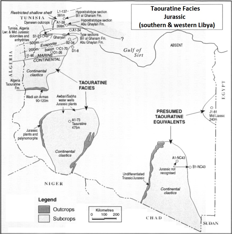
In the Murzuq Basin of Libya, however, the formation is usually limited to the continental Jurassic and assigned by Hallet (2002, p. 146)) as an undifferentiated Jurassic age. It has been mapped on the western flank of the Murzuq Basin as far south as the latitude of Ghat, beyond which the Msak Fm oversteps it. It outcrops at the foot of the great Msak escarpment. The sequence comprises numerous stacked channel-fill deposits of a braided-river system, generally 2 m to 3 m thick and 10 m to 15 m wide, with coarse-grained sandstone and lenses of the conglomerate. The formation outcrops over a wide area east and southeast of Sabha (eastern Murzuq Basin) (Figure). In the Djado Basin of Niger, no information nor formal description are available. Still, it is most likely to outcrop on the eastern side of the Basin and have the same type of depositional environment as the east of Murzuq.
Thickness: 350 m at the Type Locality in Algeria. On the western side of the Murzuq Basin, it has a thickness of 240 m. Likely to be less or equal on outcrops in eastern Djado (200? m).
[Figure. Facies and outcrops of the Taouratine Fm in southern & western Libya (Source: Modified from Hallet, 2002). At the border with Niger, the outcrops (and facies) are present in the eastern Murzuq Basin.]
Relationships and Distribution
Lower contact
In this area, the Taouratine Fm unconformably overlies the Zarzaitine Fm with a thick lateritic zone marking the junction, suggesting an extended period of sub-aerial erosion.
Upper contact
The upper contact with the overlying Msak Fm is unconformable and marked by a lateritic thin bed up to 1 m thick and composed of brownish-red to brownish-purple shales, siltstones and sandy siltstones.
Regional extent
GeoJSON
Fossils
In Libya, silicified plant remains and petrified logs. The plants and palynological assemblages confirm a Jurassic age, with no evidence of Cretaceous forms
Age
Depositional setting
Continental (lacustrine, swamp or flood plain deposit)
Additional Information